Located in north-central geopolitical zone (also called middle-belt region) of Nigeria, Kogi State was created out of the former Kwara and Benue States in 1991 covering the area of the former Kabba Province. The state is popularly called the confluence state because the confluence of River Niger and River Benue is at its capital, Lokoja, which is the first administrative capital of modern-day Nigeria.
History
The state was formed in 1991 from parts of Kwara State and Benue State with the administrative headquarters in Lokoja. The state is presently made up of the defunct Kabba Province of Northern Nigeria. The state which is structured into 21 LGA’s comprises of three major ethnic groups i.e. Igala, Ebira and Okun (Yoruba) other minor groups include – Bassa Komo, Bassa Nge, Kakanda, Kupa, Ogori-Magongo, Nupe, Oworo, Gwari etc.
It was in Lokoja that the name Nigeria was coined by Flora Shaw – later addressed as Flora Lugard after she married Lord Lugard who was a British colonial administrator – while gazing out at the river that stretched before her in the late 19th century.
People & Culture
Ebira, Igala, Nupe and Yoruba are the major languages widely spoken in the state while other languages are considered to be minority.
Farming is the main occupation of the people of the state and crops produced include cassava, yam, rice, maize, guinea corn, beans, soya beans, asha and millet. The state is blessed with precious mineral resources like columbite, coal and aquamarine.
[tab: Geography] Kogi State is bounded to the east by Nassarawa State, to the south by Enugu, Anambra and Edo States, to the west by Ondo, Ekiti and Kwara States and to the north by Niger, Abuja and Nassarawa States. The state has a land area of 29,833km. Kogi state has a total land area of 28,313.53 square kilometres and a projected population of 3.3 million people.It lies on latitude 7.49oN and longitude 6.45oE with a geological feature depicting young sedimentary rocks and alluvium along the riverbeds, which promotes agricultural activities. The state features ferrasols soil type and famous hills like ososo hills, which spread from Edo State to the western part of Kogi State and aporo hill on the eastern part. Another famous mountain is Mount Patti, which lies in Lokoja and stands at about 750 metres above sea level.

Weather/Climate
Kogi State has an average maximum temperature of 33.2°C and average minimum of 22.8°C. Lokoja, the state capital is generally hot throughout the year. The state has two distinct weather viz dry season, which lasts from November to February and rain season that lasts from March to October. Annual rainfall ranges from 1016mm to 1524mm.
The vegetation of the state consist of mixed leguminous (guinea) woodland to forest savannah. Wide expanse of fadama in the river basing and long stretches of tropical forest in the Western and Southern belt of the state.
Cities & Towns
Other important cities and towns include Lokoja, Kabba, Okene, Idah, Koton-karfe, Dekina and Ayingba.
World War Cenotaph, Lokoja: The cenotaph was built in memory of soldiers who lost their lives during the Second World War. This is a massive concrete block on top of which is mounted an old artillery. Beside it are light cannons and machine guns mounted on small pavements and the names of the soldiers who distinguished themselves during the wars were written on tables mounted on the side of the cenotaph.
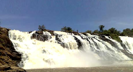
Osome Falls: Located in Ukpogo, Osome is a stream that winds its way through vast igneous rocks of varying heights and sharply descends into a valley about 50m below the towering rocks, producing thunderous sounds which could be heard about one hundred metres away.
Lord Luggard’s Residence & Office: This is the official residence and office of Lord Fredrick Luggard, the first colonial Governor General of Nigeria. The materials used in the construction of his official residence and office were imported from England.
Mount Patti, Lokoja: This is a massive hill towering over Lokoja with about 15sqkm flat top where on could see the confluence point of River Niger and River Benue.
The Iron Liberty: Located in Lokoja near the banks of River Niger, this is an important centre for slave trade during slavery era in Nigeria. It also the path through which the European explorers and missionaries in the early 19th century settled in the country.
Confluence of River Niger & Benue: River Niger remained a marvel to the Europeans until John and Richard Landers passed through the confluence in 1830, completing the journey that Mungo Park had earlier started. Rivers Niger and Benue are the two largest rivers in West Africa and the two rivers meet at Lokoja forming a Y-shaped structure and draining southwards into the ocean.. While River Niger is brownish in colour, River Benue is light green in colour. Fishing is carried on extensively on the rivers. There are ferry and boat services plus cruishing facilities within view of the confluence.
European Cemeteries: The biggest European cemetery in Nigeria with remains of european soldiers of the West African Frontier Force (WAFF) in Lokoja until 1926 and those of European missionaries. Some of the tomb stones in the cementaries date as far back as 1867.
Holy Trinity School, Lokoja: The school which was founded by the famous Bishop Ajayi Crowther in 1860, is the first primary school in Northern Nigeria. The pyramidal block of classrooms erected since its inception are still in place. The compound also houses the framed Iron of Liberty which slaves touched to regain their freedom.
Awo Tunnel: The tunnel which is about one kilometer long was dug during the reign of Onoja Obani and it serves as a hiding place for the royal family during the wars in Idah.
Koton-Karifi : Located in Okene and about 20 miles north of the confluence of the river Niger and Benue, Koton Karifi is a paradise for fishing where the locals come to fish.
Late Atta of Ebira’s Palace: Built in 1927, the palace was constructed with the combination of ancient and modern architecture.
Agbaja Plateau: Located around 14 kilometres from Lokoja, the hill is 335 to 366m above the sea level and it is a nice spot for picnic and mountaineering.
[tab: Eating Out] Not yet posted [tab: Shopping] Not yet posted [tab: Hotels] Not yet posted [tab:Gallery] Not yet posted