Located in north-central geopolitical zone of Nigeria, Kwara State is one of the most peaceful states in Nigeria. The state is known as the ‘State of Harmony’ on account of the peaceful relations that exist among its multicultural and diverse population of about 2.5 million people. Kwara State’s peaceful population, abundant natural resources, well-developed infrastructure and proactive investment-attraction policies have made it an attractive destination for investors.
History
Kwara State was created in May 1967, as one of the first of 12 states to replace the nation’s four regions. Originally the state was known as West Central State but the name was later changed to Kwara, which is a local name for the Niger River. The size of the state has been reduced over the years, as new states have been created within the federation. The total landmass of Kwara State today is around 32 500 square kilometres.
People & Culture
The main ethnic groups in Kwara are Fulanis, Nupes, Barubas and Yoruba. The state is hugely involved in agriculture and the principlal crops are Cotton, Cocoa, Coffee, Kolanut, Tobacco, Benseed and Palm produce. Mineral resources found in Kwara state are limestone, marble, feldspar, clay, kaolin, quartz and granite rocks.
Kwara state has a very rich and highly interesting cultural heritage and among these are Durbar, which is associated with Edu. The durbar is usually held in honour of a new Emir or chief, to welcome august visitors and on muslim festivals. There is also an annual boat festival called Pategi Regatta that features displays, fishing and swimming competitions.
[tab:Geography] Kwara State shares a boundary to its west with the Republic of Benin and has as its northern boundary, the Niger River. Kwara State comprises rainforest in the southern parts with wooded savannah covering the larger part of the state. The soil is fertile and the state is well watered by the various tributaries of the Niger River which run through hills and valleys, none of which rise to any great height. The western section of the state is at a slightly higher altitude than the eastern.
Cities & Towns
The capital city of Ilorin is situated 306km inland from the coastal city of Lagos and 5OOkm from the federal capital, Abuja. Major towns include Offa and Jebba, located on the Niger River. Other towns include Patigi, Erin-lIe,lIoffa, Adeleke Igbewere, Ejidongari, Osi, Lafiagi, Gure, Afon, Kaiama, Isanlu-lsin, Omu-Aran, Egbejila, lIota, Iponrin and Igbaja.
Climate
This is a summer rainfall area, with an annual rainfall range of 1000mm to 1 500mm. The months of December and January coincide with the cold and dry harmattan period. Average maximum temperatures vary between 300.C and 350.C.
Awon Festival: This is held annually at Shao, in remembrance of Awo goddess. During the festival all marriageable girls are given out in marriage in one day.
Emir’s Palace: Located at Oja Oba market in Ilorin, the palace (official residence of the Emir of Ilorin) which was built in 1993 is a popular tourist attraction. Visitors can be shown round by the palace guards known as dongari who wears red and green outfits and turbans.
Ilorin Central Mosque: The first Ilorin central mosque was founded in 1820. The present central mosque is an architectural masterpiece that attracts visitors from all over the city and beyond.
Dada Pottery, Ilorin: Located at Okelele Quarters in Ilorin, Dada pottery workshop is one of the biggest traditional pottery factories in the country. Other pottery making centres are found in Okekura, Oloje and Abemi.
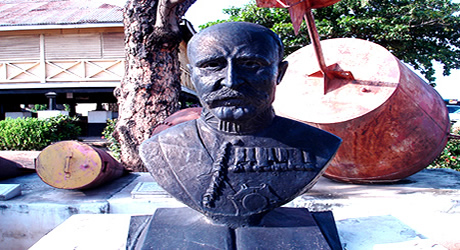
Mungo Park Cenotaph, Jebba: Mungo Park, a monument erected in memory of the activities of the European explorer is located in Jebba between the twin Jebba bridges.
Esie Museum, Esie: Located in Esie, a town 53km southeast of Ilorin in Irepodun LGA is the first museum in Nigeria established in 1945. It houses thousands of unique stone images which were found in 1775. Many myths surround the historical origin of these images which tell a lot about an older civilization. The museum houses the largest number of stone images in Black Africa.
Patigi Beach, Patigi: Patigi is located along River Niger and enjoys a bounteous stretch of sandy beach currently used by local fishermen. The regatta pavilion is constructed on the beach and together with the recently constructed regatta complex.
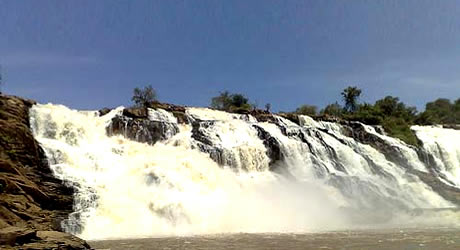
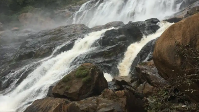
Ahoyaya Falls, Jebba: Located in Jebba, Ahoyaya falls is a pleasant site in the rainy season. Its framing waters descend on the blackish rock in a confusing pattern whose beauty and perfection could not be described by the dexterous brush of any artist.
Other places of interest include Owe Kajita falls, Tomb of past Emirs, Ubo Aiyegun Lakes, Remains of Mungo Park’s wrecked boat etc.
[tab:Eating Out] Not yet updated [tab:Hotels] Center Hotel13, Orota Way, Opposite Yidi, Ilorin
Circular Hotels Ltd.
New Yidi Road, Ilorin. Tel:031-220845, 220846
Kwara Hotel Limited
9A, Ahmadu Bello Avenue G.R.A, Ilorin. Tel: 031-221490-94, 221698-99
White House Hotels
Km 5, Lagos Road, Box 1273, Ilorin. Tel: 031-222770
Basin Road Hotel
Fate South, P.O. Box 1273, IIorin. Tel: 031-222016
Lafun Guest House
G.R.A. Omu-Aran, Irepodun L.G.A., Kwara State.
Regatta Palace Hotel
14, Reservation Road, IIorin. Tel: 031-225445
Satellite Motel
Western Reservoir Road, IIorin. Tel: 031-220244
White-House Hotels
225, Umaru Sao/Lagos Road, Sawmill (West), IIorin. Tel: 031-22770
Yebumot Hotels
Plot 6119, Western Reservation Rd. IIorin. Tel: 031-221524